Page 13 - Remembering St. Paul's Island, Part One
Published by Ronald Caplan on 1973/7/1 (6270 reads)

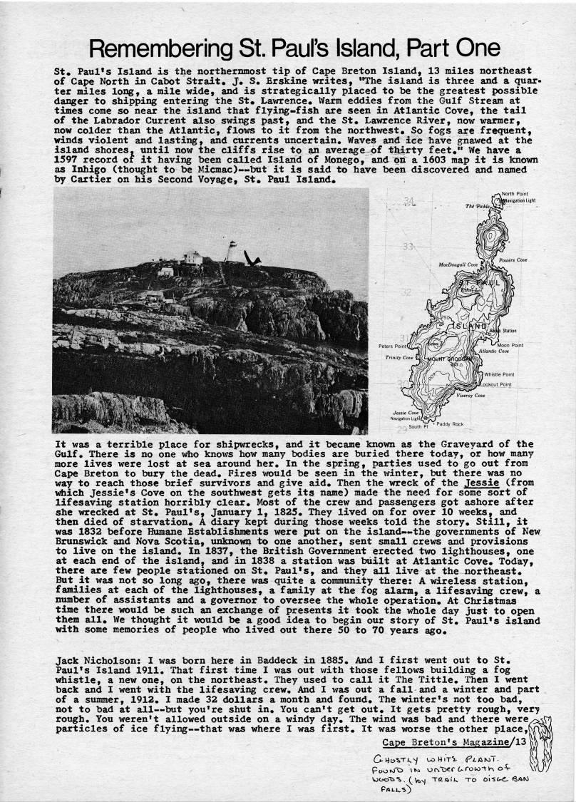
Remembering St. Paul's Island, Part One St. Paul's Island is the northernmost tip of Cape Breton Island, 13 miles northeast of Cape North in Cabot Strait. J. S. Erskine writes, "The island is three and a quar? ter miles long, a mile wide, and is strategically placed to be the greatest possible danger to shipping entering the St. Lawrence. Warm eddies from the Gulf Stream at times come so near the island that flying-fish are seen in Atlantic Cove, the tail of the Labrador Current also swings past, and the St. Lawrence River, now warmer, now colder than the Atlantic, flovrs to it from the northwest. So fogs are frequent, winds violent and lasting, and currents uncertain. Waves and ice have gnawed at the island shores, until now the cliffs rise to an average of thirty feet." We have a 1597 record of it having been called Island of Monego, and on a 1603 map it is known as Inhigo (thought to be Micmac) • but it is said to have been discovered and named by Cartier on his Second Voyage, St. Paul Island. It was a terrible place for shipwrecks, and it became known as the Graveyard of the Gulf. There is no one who knows how many bodies are buried there today, or how many more lives were lost at sea around her. In the spring, parties used to go out from Cape Breton to bury the dead. Fires would be seen in the ivinter, but there was no way to reach those brief survivors and give aid. Then the wreck of the Jessie (from vdiich Jessie's Cove on the southwest gets its name) made the need for some sort of lifesaving station horribly clear. Most of the crew and passengers got ashore after she wrecked at St. Paul's, January 1, 1825. They lived on for over 10 weeks, and then died of starvation. A diary kept during those weeks told the story. Still, it was 1832 before Humane Establishments were put on the island • the governments of New Brunswick and Nova Scotia, unknown to one another, sent small crews and provisions to live on the island. In 1837, the British Government erected two lighthouses, one at each end of the islandj and in 1838 a station was built at Atlantic Cove. Today, there are few people stationed on St. Paul's, and they all live at the northeast. But it was not so long ago, there was quite a community there: A wireless station, families at each of the lighthouses, a family at the fog alarm, a lifesaving crew, a number of assistants and a governor to oversee the whole operation. At Christmas time there would be such an exchange of presents it took the whole day just to open them all. We thought it would be a good idea to begin our story of St. Paul's island with some memories of people who lived out there 50 to 70 years ago. Jack Nicholson: I was born here in Baddeck in 1885, And I first went out to St. Paul's Island 1911. That first time I was out with those fellows building a fog whistle, a new one, on the northeast. They used to call it The Tittle. Then I went back and I went with the lifesaving crew. And I was out a fall and a winter and part of a summer, 1912. I made 32 dollars a month and found. The winter's not too bad, not to bad at all • but you're shut in. You can't get out. It gets pretty rough, ver*y rough. You weren't allowed outside on a windy day. The wind was bad and there were' particles of ice flying • that was where I was first. It was worse the other place,' Cape Breton's MaRazin


Adobe Acrobat Reader is required to the PDF version of this content. Click here to download and install the Acrobat plugin