Page 9 - The Trail to Money Point
Published by Ronald Caplan on 1973/5/1 (1459 reads)

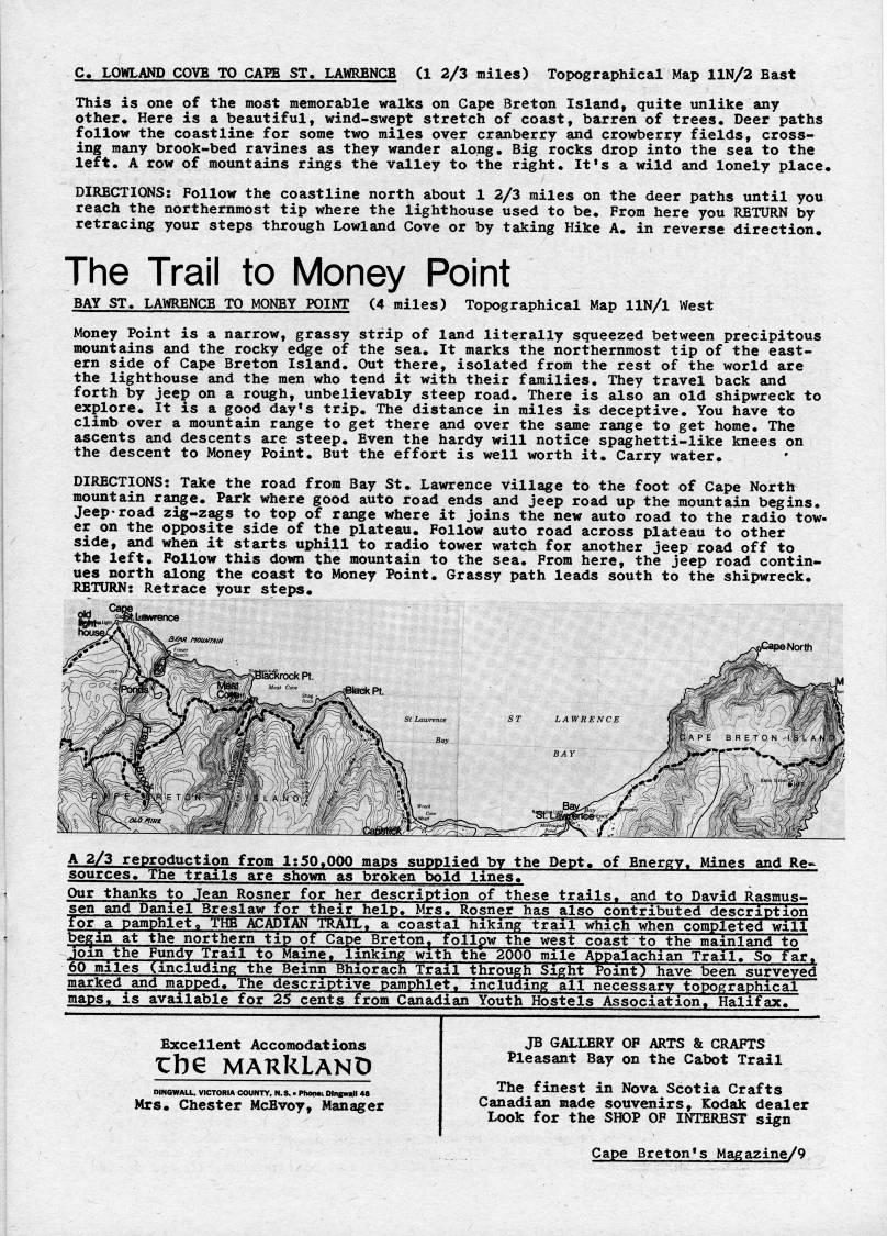
C. LOWLAND COVE TO CAPE ST. LAWRENCE (1 2/3 miles) Topographical Map llN/2 East This is one of the most memorable walks on Cape Breton Island, quite unlike any other. Here is a beautiful, wind-swept stretch of coast, barren of trees. Deer paths follow the coastline for some two miles over cranberry and crowberry fields, cross? ing many brook-bed ravines as they wander along. Big rocks drop into the sea to the left. A row of mountains rings the valley to the right. It's a wild and lonely place. DIRECTIONS: Follow the coastline north about 1 2/3 miles on the deer paths until you reach the northernmost tip where the lighthouse used to be. From here you RETURN by retracing your steps through Lowland Cove or by taking Hike A. in reverse direction. The Trail to Money Point BAY ST. LA'ifRENCE TO MONEY POINT (4 miles) Topographical Map llN/l West Money Point is a narrow, grassy strip of land literally squeezed between precipitous mountains and the rocky edge of the sea. It marks the northernmost tip of the east? ern side of Cape Breton Island. Out there, isolated from the rest of the world are the lighthouse and the men who tend it with their families. They travel back and forth by jeep on a rough, unbelievably steep road. There is also an old shipwreck to explore. It is a good day's trip. The distance in miles is deceptive. You have to climb over a mountain range to get there and over the same range to get home. The ascents and descents are steep. Even the hardy will notice spaghetti-like knees on the descent to Money Point. But the effort is well worth it. Carry water. DIRECTIONS: Take the road from Bay St. Lawrence village to the foot of Cape North mountain range. Park where good auto road ends and jeep road up the mountain begins. Jeepvroad zig-zags to top of range where it joins the new auto road to the radio tow? er on the opposite side of the plateau. Follow auto road across plateau to other side, and when it starts uphill to radio tower watch for another jeep road off to the left. Follow this down the mountain to the sea. From here, the jeep road contin? ues north along the coast to Money Point. Grassy path leads south to the shipwreck. RETURN: Retrace your steps. A 2/3 reproduction from 1:50.000 maps supplied by the Dept. of Energy. Mines and Re? sources. The trails are shown as broken bold lines. Our thanks to Jean Rosner for her description of these trails, and to David Rasmus- sen and Daniel Breslaw for their help. Mrs. Rosner has also contributed description for a pamphlet, THE ACADIAN TRAIL, a coastal hiking trail which when completed will be'in at the northern tip of Cape Breton' follpw the west coast to the mainland to be'i: , ' . 'om the Fundy Trail to Maine, ape ii So far, __' , . - -. ?? - ' - surveyed marked and mapped. The descriptive pamphlet, including all necessary topographical maps, is available for 25 cents from Canadian Youth Hostels Association. Halifax. - '' . - _ -. linking with the 2000 mile Appalachian Trail. So 0 miles (including the Beinn Bhiorach Trail through Sight Point) have been sur .-i__j • J J nr.*-- J a. _,..'' '-idmg all necessary topographi Excellent Accomodations Zh?? MAKklAND DINGWALL, VICTORIA COUNTY, N.S, • PIMKMiDIngWAll 4S Mrs. Chester McBvoy, Manager JB GALLERY OF ARTS & CRAFTS Pleasant Bay on the Cabot Trail The finest in Nova Scotia Crafts Canadian made souvenirs, Kodak dealer Look for the SHOP OF INTEREST sign Cape Breton's Magazine/9


Adobe Acrobat Reader is required to the PDF version of this content. Click here to download and install the Acrobat plugin