Page 32 - Capt. Holland's Plan for Cape Breton, 1767
Published by Ronald Caplan on 1983/6/1 (372 reads)

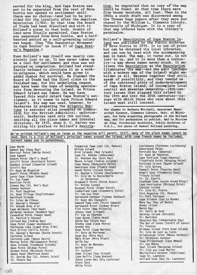
served for the king. And Cape Breton was not to be separated from the rest of Nova Scotia nor opened to settlement until there was no choice--land had to be pro? vided for the Loyalists after the American Revolution (1784). By that time the Board of Trade had been dissolved and with it Holland's pleas to that body. Grants of land were finally permitted, Cape Breton was separated from Nova Scotia, and a half? hearted period as a self-governing colony was begun. (See "The Separatist Movement in Cape Breton" in Issue 27 of Cape Bret? on's Magazine.) Even Holland's map itself was nearly com? pletely lost to us. It was never taken up as a tool for settlement and thus was not printed on completion. Holland had stead? fastly refused to circulate it as a work- in-progress, which would have given it added chance for survival. He claimed the Board of Trade had the first claim to the finished map, but his underlying reason may have been the hope of keeping specula? tors from devouring the island, as Prince Edward Island was taken. He may have feared this woi'ld retard Cape Breton's set? tlement, as it seems to have Prince Edward Island's. His map was used, however, by .DesBarres in preparing the Atlantic Nep? tune (a seacoast atlas prepared on coiranis- sion for the British Admiralty); unfortun? ately, DesBarres used only the outline, omitting all the place names and internal divisions. By 1935, when D. C. Harvey was writing his preface to Holland's Descrip? tion, he regretted that no copy of~the map could be found. At that time there were five known versions, all lost. Then in the 1960s a sixth draft was discovered among the Thomas Gage papers after they were pur? chased by the William L. Clements Library, University of Michigan. It is a copy of that map offered here with the library's permission. Holland's Description of Cape Breton Is? land was published by the Public Archives of Nova Scotia in 1935. It is out of print but can be obtained via local libraries, and can now be read with the accompanying map in hand. The map, it turns out, is not lost to us, and it is more than a curios- ity--a map whose names never stuck. It en? livens the Description as the Description illuminates the map--and the pair (perhaps with a modem map of the island) might em? bolden us all. Because together they still speak of possibility, and they remind us of the continued story of underdevelopment of Cape Breton Island, of incomplete local control and absentee ownership--18th-cen? tury issues that plagued this island in the 19th and into the 20th centuries--is- sues with which those who care about this island must still contend. Our thanks to Barbara Mitchell, Assistant Manu? script Curator, Clements Library, Univ. of Michi? gan, for help acquiring photographs of the Holland map, and for permission to publish. And to Nicolas de Jong, Provincial Archivist, Public Archives of P.E.I., for photo of Samuel Holland painting. We've printed Holland's map as large as the magazine will permit. Still, many of the place names cannot be read. Here is a list of Holland's principal names around the island, with some French names he included. Current names are in parentheses. Cape North Egmont Bay (Aspy Bay) Percival Point (White Point) Cape Egmont Enmore Point (Neil's Head) Colvill Point (Archibald Point) Dundass Island (Ingonish Island) Colvill Bay Fr: Baye de Niganish Durell Point (Middle Head) Lenox Cape (Cape Smokey) Fr: Cap Fumee Bentinck Point Conway Bay (St. Ann's Bay) Conway Harbour Fr: Port Dauphine St. Anne Village (Englishtown) Hertford Islands Fr: Isles de Ciboux St. George's Channel Fr: Grande Bras d'or Cape Welderen (Red Head) Welderen Harbour (Baddeck Bay) Cavendish Point (Kempt Head) St. Patrick's Channel Col lard Bay (Indian Bay) Hope Point (Lower Washabuck) Shelburne Lake (Lower Bras d'Or) Port Elliot (Gillis Point) St. George's Narrows (Barra Strait) Carleton Island Carleton Lake (Denys Basin) Murray Point (Malagawatch Point) Dean Islands (Crammond Islands) Dean Point (Widows Point) Gordon Point (Mcintosh Point) Owens Head (Morrison Head) St. Davids Bay (St. Peters Inlet) St. Peters Bay Frederick Town Lott (St. Peters) Wilson Island Bird Islands (Red Islands) Cape St. Andrew (Johnstown) St. Andrews Bay (East Bay) Moore Island (Indian Islands) Cape Denny (Benacadie Point) Hewitsons Cove (Pipers Cove) Heath Point (Island Point) St. George's Island (Boularderie) Fr: Isle de la Boularderie or Verderone Brudenell Point (Point Aconi) Fr: Pointe Cunnet Bouquet Point (Alder Point) Cumberland Cape (Cranberry Point) Fr: Cap aux Paum Dartmouth Harbour (Sydney Harbour) Fr: Baye des Espagnols Edward Town Lott (Point Edward) Dartmouth River (Sydney River) Flat Point (New Victoria) Jenyns Cape (Lingan) Fr: Cap au Charbon Cape Dyson (Table Head) Dyson Bay (Glace Bay) Granby Cape (Cape Perce) Granby Bay Gage Point (Cape Mori en) Fr: Baie de Marienne Gage Bay (Mira Bay) Mary River (Mira River) Wolfe Bay Fr: Baye de Menadou Wolfe Island Fr: Scatari Howe Island (Hay Island) Cape Wall is (Cape Breton) Great Loren Bee (Big Lorraine) Black Rock White Point Louisbourg (Fortress Louisbourg) Kennington Point Portland Bay (Gabarus) Fr: Baye de Gabarous Cape Portland (Cape Gabarus) Titchfield Point (Winging Point) Portland Island (Guyon Island) Fr: Isle Guiong Pownell Point (Fourchu Head) Orwell Cove (Framboise Cove) Tilbury Island Fr: St. Esprit Stanhope Cove (mouth Grand River) Cape Harrington (Michaud Point) Chester Island Fr: Isle St. Pierre Port Augustus (St. Peters) Fr: Port Toulouse Cape Kildare (Cap La Ronde) Mary Bay (Bay of Rocks) Green Island March Bay Fr: Petit de Grat Darnley Island (Arichat) Fr: Narichat Douglass Bay (Inhabitants Bay) The Gut of Canso (Strait of Canso) Fr: Fronsac Wildman Island (Port Hood Island) Fr: Isle de Just au Corps Hilsborough Inlet (Mabou Harbour) Fr: Peintures Harbour Cape Hilsborough (Cape Mabou) Fr: Cap Mabou Seal Island (Margaree Island) Fr: Isle aux Loup Marins Maclesfield Harbour (Cheticamp) Cape St. Lawrence Holland Cove (Bay St. Lawrence) (32)


Adobe Acrobat Reader is required to the PDF version of this content. Click here to download and install the Acrobat plugin