Page 30 - C.B.'s Geology: A Talk on the Rocks!
Published by Ronald Caplan on 1993/1/1 (267 reads)

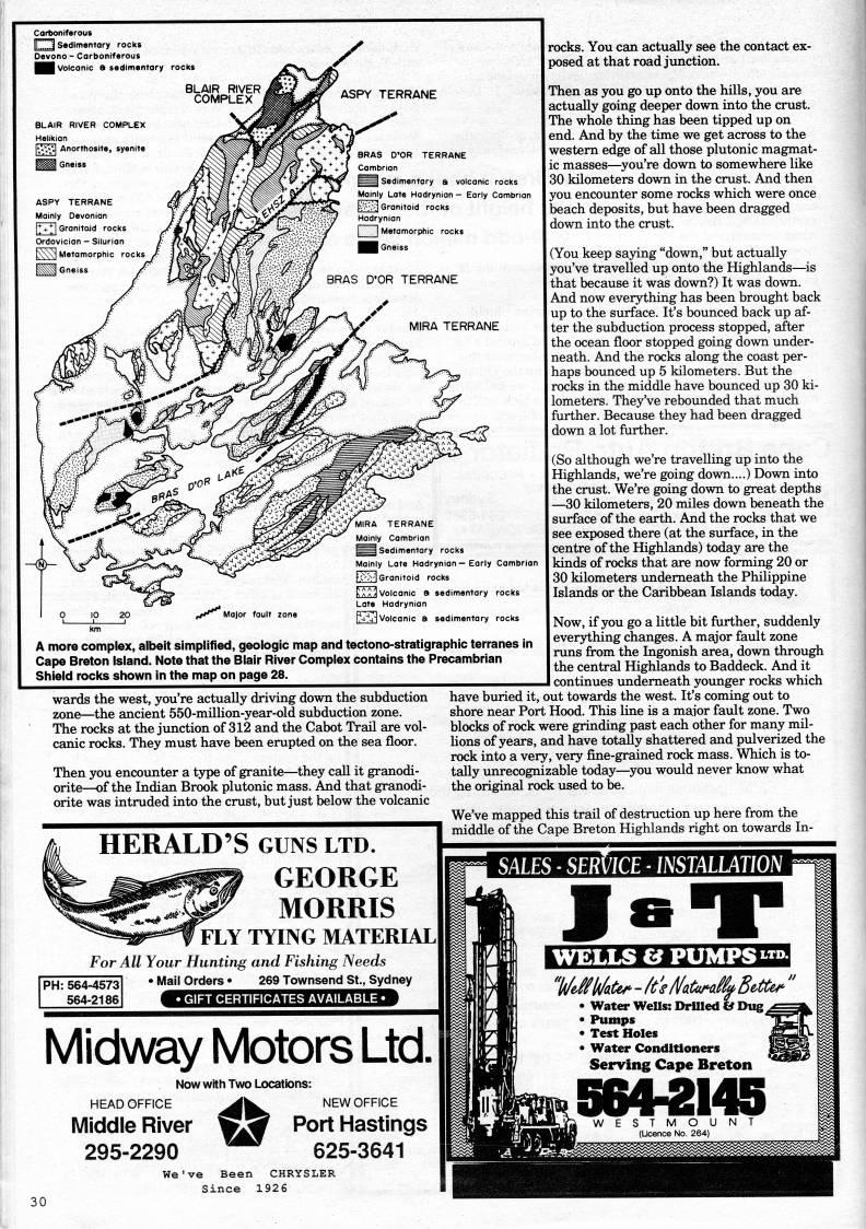
Carfeoniferous K...3 Sedimentary rocks Devono - Carboniferous Hm Volcanic a sedimentary rocks BLAIR RIVER COMPLEX Helikion |>y • | Anorthosite, syenite A more complex, albeit simplified, geologic map and tectono-stratigraphic terranes in Cape Breton Island. Note that the Blair River Complex contains the Precambrian Shield rocks shown in the map on page 28. wards the west, you're actually driving down the subduction zone • the ancient 550-million-year-old subduction zone. The rocks at the jimction of 312 and the Cabot Trail are vol? canic rocks. They must have been erupted on the sea floor. Then you encounter a type of granite • they call it granodi- orite • of the Indian Brook plutonic mass. And that granodi- orite was intruded into the crust, but just below the volcanic HERALD'S GUNS ltd. GEORGE MORRIS ' FLY TYING MATERUL For All Your Hunting and Fishing Needs PH: 564-4573 564-2186 • Mail Orders • 269 Townsend St., Sydney • GIFT CERTIFICATES AVAILABLE • Midway Motors Ltd. Now with Two Locations: HEAD OFFICE '' NEW OFFICE Middle River wSf Port Hastings 295-2290 '"' 625-3641 We've Been CHRYSLER Since 1926 rocks. You can actually see the contact ex? posed at that road junction. Then as you go up onto the hills, you are actually going deeper down into the crust. The whole thing has been tipped up on end. And by the time we get across to the western edge of all those plutonic magmat? ic masses • you're down to somewhere like 30 kilometers down in the crust. And then you encounter some rocks which were once beach deposits, but have been dragged down into the crust. (You keep saying "down," but actually you've travelled up onto the Highlands • is that because it was down?) It was down. And now everything has been brought back up to the surface. It's bounced back up af? ter the subduction process stopped, after the ocean floor stopped going down under? neath. And the rocks along the coast per? haps bounced up 5 kilometers. But the rocks in the middle have bounced up 30 ki? lometers. They've rebounded that much further. Because they had been dragged down a lot further. (So although we're travelling up into the Highlands, we're going down....) Down into the crust. We're going down to great depths • 30 kilometers, 20 miles down beneath the surface of the earth. And the rocks that we see exposed there (at the surface, in the centre of the Highlands) today are the kinds of rocks that are now forming 20 or 30 kilometers underneath the Philippine Islands or the Caribbean Islands today. Now, if you go a little bit further, suddenly everj'hing changes. A major fault zone runs from the Ingonish area, down through the central Highlands to Baddeck. And it continues underneath yomiger rocks which have buried it, out towards the west. It's coming out to shore near Port Hood. This line is a major fault zone. Two blocks of rock were grinding past each other for many mil? lions of years, and have totally shattered and pulverized the rock into a very, very fine-grained rock mass. Which is to? tally unrecognizable today • you would never know what the original rock used to be. We've mapped this trail of destruction up here from the middle of the Cape Breton Highlands right on towards In- mm SALES-SERVICE-mTAllAnON WELLS & PUMPS'' • • Water WeUs: DriUed fcf Dug > • Pumps • Test Holes • Water Conditioners Serving Cape Breton


Adobe Acrobat Reader is required to the PDF version of this content. Click here to download and install the Acrobat plugin