Page 50 - A Taste of Hiking Trails of Cape Breton: A New Book by Michael Haynes
Published by Ronald Caplan on 1999/6/1 (746 reads)
 Page 49 - The Sinking of the Patrick Morris - One Sailor's Day
Page 51 - A Visit With the MacLeods at Belfry

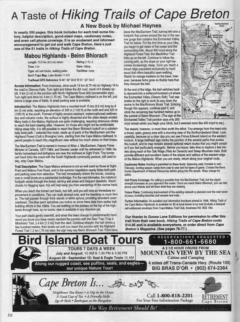
A Taste of Hiking Trails of Cape Breton A New Book by Michael Haynes In nearly 300 pages, this book includes for each trail some his? tory, helpful description, good-sized maps, cautionary notes, and even cell phone coverage. It is an exuberant and informed encouragement to get out and walk Cape Breton. Here's just one of the 51 trails in Hiking Trails of Cape Breton. Mabou Highlands - Beinn Bhiorach Length: 10.5 km (6.5 mi) return Rating (1 -5): 3 Time: 3 hr Uses: liildng Type: old cart tracks, walking paths Facilities: none Gov't Topo Map: Lake Ainslie 11 K/3 Trailhead GPS Reference: N 46? 08" 59.8' W 61 ? 22" 54.0' Access Information: From Inverness, drive south 14 km (8.75 mi) on Highway 19 to the road to Glenora Falls. Turn right and follow the dirt road, much of it steeply up? hill, 5 km (3 mi) to the junction with North Highlands Road 600 (snowmobile sign). Turn right and drive for 3 km (1.75 mi). The Cape Mabou trailhead is on the left, just before a large area of fields. A small parking area is available. Introduction: The fulabou Highlands fomn a rounded knoll 15 km (9.5 mi) long by 8 km (5 mi) wide, reaching an elevation of 335 m (1100 ft) at the north end and 320 m (1050 ft) at the south. Formed of highly erosion-resistant, metamorphosed sedimen? tary and volcanic rocks, the surface is highly dissected and the sides deeply eroded. Many trails in the Mabou Highlands are quite challenging, requiring strenuous climbs to reach the best viewing sites. However, for those who might not be comfortable hiking steep hills, it is still possible to reach the Beinn Bhiorach lookoff on a substan? tially level path. I selected this route, made up of parts of the MacEachem and the Highland Forest (Colli a Bhraighe) trails, starting from the Cape Mabou trailhead, to permit people to reach this magnificent view wittiout too much stress on their knees. The MacEachem Trail is named in honour of Allan J. MacEachem, Deputy Prime Minister of Canada, 1977-1984, and Senate Leader until his retirement in 1996; his family homestead and birthplace are near the trailhead at Sight Point. The former cart track links the coast with the South Highlands community pasture, still used to? day, atop Cape Mabou. Trail Description: The Cape Mabou entrance is not as well used as those at Sight Point and Mabou Post Road, and in the summer vegetation nearly hides both path and parking area from detection. The trail immediately enters the woods, crossing over a small brook on a substantial footbridge. For the next kilometre, the indistinct footpath winds through the forest, skirting wet areas and frequent deadfalls. Watch closely for flagging tape; this will help keep you from wandering off the narrow track. When you reach the former cart track, turn left, and you will note an immediate im? provement in conditions. Two can walk abreast now, and the treadway is much firm? er. The trail passes through thick stands of white spruce, providing abundant cover overhead. The blue paint splotches you notice on some trees date from earlier trail- building efforts in the 1980s. You are walking on the plateau on the top of the high? lands through here, so no scenic view is available in any direction yet. Your path leads gently downhill, and when the trees change to predominantly hard? wood you know you have nearly reached the junction with the Bear Trap (Trap a Mhathain) Trail, 2.4 km (1.5 mi) from the start. Continue straight; the trail climbs a few hundred metres, then levels out until you reach the junction with the Highland Forest Trail 1.2 km (.75 mi) later; the sign may say Beinn Bhiorach Trail. From here, leave the MacEachem Trail, turning left onto a footpath that curves around the top of the nar? row gorge that contains the Enchanted Valley Trail far below. For the first time on your hike, you begin to get views of the ocean and the surrounding hills. About 300 m/yd along the Highland Forest Trail, the MacArthur Trail links up on the left. Continue to follow the cun/ing path, as the slope on your right be? comes increasingly steep. Soon you reach a broad ridge populated exclusively by hard? wood that offers beautiful open walking. Watch for orange markers on the trees, how? ever, because fems grow so thickly here that they obscure the trail. At the end of the ridge, the trail switches back to descend into a softwood-forested col where the Enchanted Valley (Gleann Sidh) Trail sep? arates on the right to work its way down the ravine to the MacKinnons Brook Trail. Enticing though this appears, continue past it, and climb the remaining few hundred metres up to the summit of Beinn Bhiorach. (The sign at the Enchanted Valley Trail junction says only 200 m/yd remain when you begin your climb, but it seemed more like 400 m/yd to me.) The reward, however, is more than worth the effort. You emerge from the trees onto a broad, open, grassy area with a stunning view of the Northumberiand Strait. Look carefully, because on a clear day you can see Prince Edward Island on the western horizon. A large trailhead sign marks the junction of the several paths that access this lookoff, and its map reveals several optional retum routes that you might consid? er if you feel particularly energetic. Before you leave, take time to explore a few me? tres along each of the Oak Ridge (Rids An Daraich) and Steep Mountain trails. Both provide different and excellent views of the slopes and valleys of the western edge of the Mabou Highlands. When you are ready, retum along your original route. Cautionary Notes: Hunting is permitted on these lands. Spanning early October to mid- February, hunting season varies from year to year and for types of game. Contact the Nova Scotia Department of Natural Resources before going into the woods. Wear orange for safety. Cell Phone Coverage: No calling is possible from the MacEachem Trail, but the signal strength increases as you approach the ocean. Once you reach Beinn Bhiorach, you can tele? phone your friends and tell them what they are missing. Future Plans: Continuing improvement of the existing network is planned over the next sever? al years, including benches and several new trails. Further Information: An excellent and informative brochure printed in 1998, Hildng Trails of the Cape Mabou Highlands, is available for $2 at local stores or by mail (include a stamped self-addressed envelope) from Cape MaBou Trail Club, Inverness NS BOE 1N0. Our thanks to Goose Lane Editions for permission to offer this trail from their new book. Hiking Trails of Cape Breton costs $14.95 and is available everywhere, or order direct from Cape Breton's Magazine. (See pages 76-77.) Bird Island Boat Tours RESERVATIONS 1-800-661-6680 TOURS 7 DAYS A WEEK July and August: 10 AM & 1:30 PM & 5:30 PM August 28 - September 15: Seal & Eagle Tours 10 AM Along our rugged coast, see puffins, seals, and eagles • our unique Nature Tour! A 2 1/2 HOUR CRUISE FROM MOUNTAIN VIEW BY THE SEA t Cabins and Camping , 4 miles off Trans-Canada Hwy. (Route 105) ( BIG BRAS D'OR • (902) 674-2384 • Breton Is... '''y''' Neighbours You Know • A Dip in the Ocean A Good Cup of Tea • A Friendly Hello Jigs & Reels • Barbeques at the Bungalow Call 1-800-818-2201 For Your Free Information Package RETIREMENT Cape Breton The Way Retirement Should Be!


Page 49 - The Sinking of the Patrick Morris - One Sailor's Day
Page 51 - A Visit With the MacLeods at Belfry
Adobe Acrobat Reader is required to the PDF version of this content. Click here to download and install the Acrobat plugin