Page 24 - A Theory of the Vikings on Cape Breton
Published by Ronald Caplan on 1977/12/1 (444 reads)

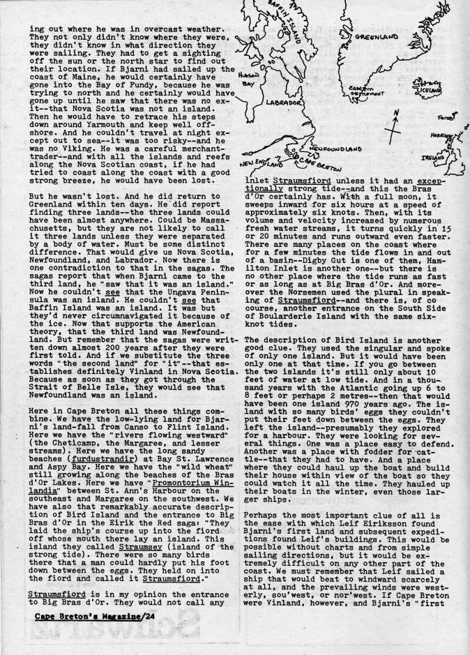
ing out where he was in overcast weather. They not only didn't know where they were, they didn't know in what direction they were sailing. They had to get a sighting off the sun or the north star to find out their location. If Bjarni had sailed up the coast of Maine, he would certainly have gone into the Bay of Fundy, because he was trying to north and he certainly would have gone up until he saw that there was no ex? it • that Nova Scotia was not an island. Then he would have to retrace his steps down around Yarmouth and keep well off? shore. And he couldn't travel at night ex? cept out to sea • it was too risky • and he was no Viking. He was a careful merchant- trader • and with all the islands and reefs along the Nova Scotian coast, if he had tried to coast along the coast with a good strong breeze, he would have been lost. But he wasn't lost. And he did return to Greenland within ten days. He did report finding three lands • the three lands could have been almost anywhere. Could be Massa? chusetts, but they are not likely to call it three lands unless they were separated by a body of water. Must be some distinct difference. That would give us Nova Scotia, Newfoundland, and Labrador. Now there is one contradiction to that in the sagas. The sagas report that when Bjarni came to the third land, he "saw that it was an island." Now he couldn't see that the Ungava Penin? sula was an island. He couldn't see that Baffin Island was an island. It was but they'd never circumnavigated it because of the ice. Now that supports the American theory, that the third land was Newfound- Isund. But remember that the sagas were writ? ten down almost 200 years after they were first told. And if we substitute the three words " the second land" for "it" • that es? tablishes definitely Vinland in Nova Scotia. Because as soon as they got through the Strait of Belle Isle, they would see that Newfoundland was an island. Here in Cape Breton all these things com? bine. We have the low-lying land for Bjar? ni 's land-fall from Canso to Flint Island. Here we have the "rivers flowing westward" (the Cheticamp, the Margaree, and lesser streams). Here we have the long sandy beaches (furdustrandir) at Bay St. Lawrence and Aspy Bay. Here we have the "wild wheat" still growing along the beaches of the Bras d'Or Lakes. Here we have "Promontorium Win- landia" between St. Ann's Harbour on the southeast and Margaree on the southwest. We have also that remarkably accurate descrip? tion of Bird Island and the entrance to Big Bras d'Or in the Eirik the Red sagas "They laid the ship's course up into the fiord off whose mouth there lay an island. This island they called Straumsey (island of the strong tide). There were so many birds there that a man could hardly put his foot down between the eggs. They held on into the fiord and called it Straumsfiord." Straiimsfiord is in my opinion the entrance to Big Bras d'Or. They would not call any Cape Breton's Magagine/24 G-R • ffNL'MO r/<>?ir N i ftunie? '''. ,/' . . inlet Straumsfiord unless it had an excep? tionally strong tide-'-and this the Bras d'Or certainly has. Vfi'th a full moon, it sweeps inward for six hours at a speed of approximately six knots. Then, with its volume and velocity increased by numerous fresh water streams, it turns quickly in 15 or 20 minutes and runs outward even faster. There are many places on the coast where for a few minutes the tide flows in and out of a basin • Digby Gut is one of them, Ham? ilton Inlet is another one • but there is no other place where the tide runs as fast or as long as at Big Bras d'Or. And more? over the Norsemen used the plural in spesJc- ing of Straumsfiord • and there is, of co course, another entrance on the South Side of Boularderie Island with the same six- knot tides. • The description of Bird Island is another good clue. They used the singular and spoke of only one island. But it would have been only one at that time. If you go between . the two islands it's still only about 10 feet of water at low tide. And in a thou- samd years with the Atlantic going up 6 to 8 feet or perhaps 2 metres • then that would have been one island 970 years ago. The is? land with so many birds' eggs they couldn't put their feet down between the eggs. They left the island • presumably they explored for a harbour. They were looking for sev? eral things. One was a place easy to defend. Another was a place with fodder for cat? tle • that they had to have. And a place where they could haul up the boat smd build their house within view of the boat so they could watch it all the time. They hauled up their boats in the winter, even those lar? ger ships. Perhaps the most important clue of all is the ease with which Leif Eiriksson found Bj ami's first land and subsequent expedi? tions found Leif's buildings. This would be possible without charts and from simple sailing directions, but it would be ex? tremely difficult on any other part of the coast. We must remember that Leif sailed a ship that would beat to windward scarcely at all, and the prevailing winds were west? erly, sou'west, or nor'west. If Cape Breton were Vinland, however, and Bj ami's "first


Adobe Acrobat Reader is required to the PDF version of this content. Click here to download and install the Acrobat plugin